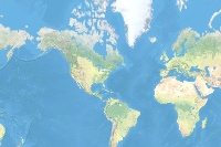
This layer portrays elevation as an artistic hillshade. The map is designed to be used as a backdrop for topographic, soil, hydro, landcover or other outdoor recreational maps. A brief summary of the item is not available. Add a brief summary about the item.
![]() Tile layer
from
Tile layer
from
Item created: Jul 9, 2015 Item updated: Nov 27, 2024 View count: 355,379,998
Description
This layer portrays elevation as an artistic hillshade. The map is designed to be used as a backdrop for topographical, soil, hydro, landcover or other outdoor recreational maps. It’s a default relief background in various basemaps such as Topographic, Terrain with Labels.
The map is compiled from a variety of data sources from commercial, community maps and many authoritative organizations across the globe. The basemap has global coverage down to a scale of ~1:72k. In the United States, parts of Europe, Asia and Africa coverage goes down to ~1:9k.
To see the coverage and sources of various datasets comprising this map layer, view the Elevation Coverage Map. Additionally, this layer uses data from Maxar’s Precision 3D Digital Terrain Models for parts of the globe.
The map is based on the Multi-directional hillshade algorithm.
An in-depth description of the item is not available.
Tables
Basemap
Project Contents:
Solution Contents
Contents
Layers
Screenshots
Terms of Use
 This work is licensed under the Esri Master License Agreement.
No special restrictions or limitations on using the item's content have been provided.
Details
Dashboard views: Desktop
Source: Map Service
Creating data in:
Published as:
Other Views:
Dependent items in the recycle bin
Applicable: 2d
Size: 1 KB
ID: 1b243539f4514b6ba35e7d995890db1d
Image Count: 0
Image Properties
Layer Drawing
Using tiles from a cache
Dynamically from data
Share
Owner
Folder
Categories
This item has not been categorized.
Credits (Attribution)
No acknowledgements.Sources: Esri, Maxar, Airbus DS, USGS, NGA, NASA, CGIAR, N Robinson, NCEAS, NLS, OS, NMA, Geodatastyrelsen, Rijkswaterstaat, GSA, Geoland, FEMA, Intermap, and the GIS user community
Comments (4)
Today the shaded layer is not loaded. What's the problem, we have all the maps with this background!!
There is an error in the map in northern Clay County, Missouri that needs to be corrected. The error can be seen if zoomed in closer than 1:95000
Finland is listed twice in the description of coverage; I wonder if one of the two mentions of "Finland" was meant to be Sweden?
The Shark Valley Visitor Center Everglades National Park has a new location and building site. The road does not continue through. 25.756767 -80.766419