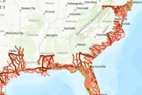
This feature layer, utilizing data from Homeland Infrastructure Foundation Level Data, displays the locations of hurricane evacuation routes in the United States. These are designated routes used to direct traffic inland in case of a hurricane threat. A brief summary of the item is not available. Add a brief summary about the item.
![]() Feature layer
by
Feature layer
by
Item created: Apr 6, 2020 Item updated: Feb 6, 2025 View count: 1,879,812
Description
Hurricane Evacuation Routes
This feature layer, utilizing data from Homeland Infrastructure Foundation Level Data (HIFLD), displays the locations of hurricane evacuation routes in the United States. Per HIFLD, "A hurricane evacuation route is a designated route used to direct traffic inland in case of a hurricane threat. This dataset is based on supplied data from Gulf Coast and Atlantic Seaboard states. The GIS data was gathered from states willing to share such data. Three (3) states (ME, NY, and NH) indicated that they do not maintain public maps showing hurricane evacuation routes and were unable or unwilling to share GIS files depicting such routes."
Houston, Texas area hurricane evacuation routes
Data currency: Caution should be exercised by the user of this feature layer. This data is over seventeen years old and has not been updated since creation. HIFLD is inquiring with agencies to determine whether they would be willing to be data stewards for this layer going forward. (As of January 2018)
Data source: Hurricane Evacuation Routes
Data modification: None
For more information: Homeland Infrastructure Foundation- Level Data Subcommittee
Support documentation: Metadata
For feedback, please contact: ArcGIScomNationalMaps@esri.com
Homeland Infrastructure Foundation-Level Data (HIFLD) Subcommittee
Per HIFLD, "The Homeland Infrastructure Foundation-Level Data (HIFLD) Subcommittee was established…to address improvements in collection, processing, sharing, and protection of homeland infrastructure geospatial information across multiple levels of government, and to develop a common foundation of homeland infrastructure data to be used for visualization and analysis on all classification domains."
An in-depth description of the item is not available.
Tables
Basemap
Project Contents:
Solution Contents
Contents
Layers
Screenshots
Terms of Use
 This work is licensed under the Esri Master License Agreement.
No special restrictions or limitations on using the item's content have been provided.
Details
Dashboard views: Desktop
Source: Feature Service
Creating data in:
Published as:
Other Views:
Dependent items in the recycle bin
Applicable: 2d
Data updated: Sep 27, 2024, 3:35 PM
Schema updated: Sep 27, 2024, 3:44 PM
Size: 1 KB
ID: 29f5a1e6bf1e4394a692ba633d5c8af6
Image Count: 0
Image Properties
Layer Drawing
Using tiles from a cache
Dynamically from data
Share
Owner
Folder
Categories
This item has not been categorized.
Credits (Attribution)
No acknowledgements.Homeland Infrastructure Foundation-Level Data (HIFLD)
Comments (2)
GEOL, LSC JB 04/25/2023
This is the evacuation layer of my map