Skip to content
Loading…
This layer is editable and shared with the public. To prevent unwanted editing, unshare this item or approve it for public data collection.
Finish setting up your layer
Describe your item below. Add fields on the Data tab. Configure editing on the Settings tab. Configure drawing and pop-ups through Map Viewer or Visualization tab.

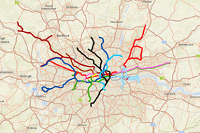
A geographically accurate representation of the London Underground network. The web map displays a true representation of the London Undersground network. A brief summary of the item is not available. Add a brief summary about the item.

‎Web Map by

New notebook runtime available. You can update the runtime from the settings tab of the item details page.

Item created: Feb 22, 2012 Item updated: Sep 17, 2018 View count: 382,395

Snapshot last refreshed:

1894 characters left.

Description

The London Underground map, first developed by Harry Beck in 1931, is world famous as being an iconic schematic diagram, however as many know it isn't geographically accurate. This map shows the real route of the Tube and its stations.

At closer zoom scales you can also turn on 5 minute average walk times (please note, these are off by default) around each underground station. This distance is based on an average walking speed of 5 km/hr. These were calculated by generating geodesic buffers using ArcGIS for Desktop.


An in-depth description of the item is not available.

Tables

Project Contents:

Solution Contents

Contents

Layers

Screenshots

Terms of Use

Line routes and station locations were manually digitised. More recent stations and lines were taken from OpenStreetMap.  

OpenStreetMap® is open data, licensed under the Open Data Commons  Open Database License (ODbL) by the OpenStreetMap Foundation (OSMF).
The full legal code explains your rights and responsibilities.
The cartography in our map tiles, and our documentation, are licenced under the Creative Commons Attribution-ShareAlike 2.0 licence (CC BY-SA).

No special restrictions or limitations on using the item's content have been provided.

Comments (6)

Sign in to add a comment.

bbxsbsdl Item Owner commented 4 years ago Delete Reply

Did you block the conversion to kml, your posted elaborate geographic routes?

Esri_UK Item Owner commented 4 years ago Delete

Hi there, Thanks for your question. As this web map is a tiled map service, unfortunately the options to export things like KML is currently unavailable. We apologise for the inconvenience.

isaberebitrus Item Owner commented 5 years ago Delete Reply

Great work, am still looking forward to when i will come up with one for my country in Africa.

Javier.Ruiz.Ramos Item Owner commented 6 years ago Delete Reply

Nice! I did a very similar map of the London Overground a few months ago since I could not find any precise London tube map. It took me a while to generate Underground lines from stations locations... Having this would have been much better :). Great work,

Galverion Item Owner commented 12 years ago Delete Reply

Just the other week I was wondering whether a "true" map of the Underground has ever been done...well, here it is !

cwheeler Item Owner commented 13 years ago Delete Reply

This is great. I have been working on similar - but yours is better! Any chance of London Overground??!! P.S. I thought I had rated it 5 star, but it showed up as 4 for some reason - sorry

Item Information

LowHigh

Item Information

LowHigh

Make your item easy to find, understand, and use by providing this information.

    Details

    Dashboard views: Desktop

    Creating data in:

    Published as:

      Other Views:

        Dependent items in the recycle bin

          Applicable: 2d

          Size: 1.769 KB

          Attachments size: 0 KB

          ID: 8a567ebac15748d39a747649a2e86cf4

          Image Count: 0

          Image Properties

          Layer Drawing

          Using tiles from a cache

          Dynamically from data

          Share
          Owner

          Esri_UK

          Folder

          Categories

          This item has not been categorized.

          Assign Category
          Credits (Attribution)
          No acknowledgements.

          Map data (c) OpenStreetMap contributors, CC-BY-SA

          URL View
          WMTS View
          Your tile layer is ready to use
          This tile layer will automatically create tiles as needed and cache them for future use. No further configuration is required. View the Settings tab to change the default options. Build tiles manually for specific scales and extents to improve display performance for the first person to view the tile layer at that scale and extent. Tiles must exist if the layer will be used offline.
          All items were exported successfully
          ${numberOfItems} item(s) were exported successfully. Some item(s) skipped or failed to export.
          See description for more information
          Cannot import
          Export packages from newer portal versions cannot be imported to older versions.
          Loading…